Mahan Rykiel Research Director Isaac Hametz will be presenting at the Western Dredging Association 2019 Expo.
The full program can be found here
COMMUNITY-BASED BENEFICIAL USE FOR SEA LEVEL RISE: A CO-BENEFITS STRATEGY FOR DREDGED MATERIAL MANAGEMENT
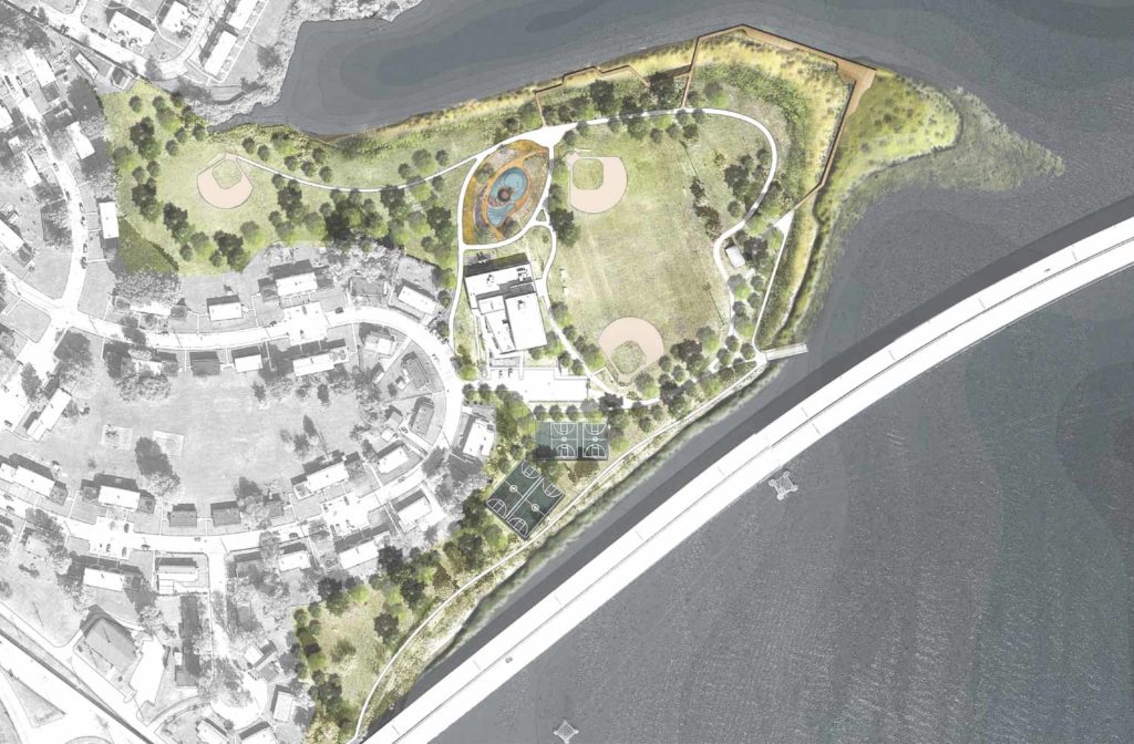
Sea level rise presents challenges and opportunities for dredged material management planning and construction. Understanding how to navigate the sociopolitical, economic, and environmental parameters of these increasingly common project types is essential to successful outcomes. In this context small-scale, community-based projects that utilize fine silts and clays represent an underexplored project type for sea level rise planning and construction. This project type is not intended to replace the capacity provided by more conventional large scale dredging projects; however, as part of an expansion of dredging operations that address climate adaptation and sea level rise, it may present unique co-benefit opportunities for government, community, and private sectors stakeholders. To that end, this paper presents a case study of Fleming Park, an ongoing Community-Based Beneficial Use (CBBU) for sea level rise project in Turner Station, Maryland. The project includes robust community engagement processes, integrated landscape architectural design, research, and engineering, and coordinated regulatory interactions. These elements form the backbone of the project’s co-benefits strategy, which have coalesced a partnership group that includes the Turner Station Conservation Teams, Chesapeake Bay Foundation, elected officials, government regulators, academic institutions, and private sector companies. These partners aim to integrate community needs and aspirations with sea level rise planning and capacity/placement through living shorelines, thin layer marsh restoration, and upland placement. This community-based approach to beneficial use responds to the most up-to-date climate science (IPCC, Climate Assessment, etc.), which predicts Maryland to be the second most chronically flooded state in the nation. In addition, the project advances the goals of Maryland’s 2001 Dredged Material Management Act, which calls for a rolling 20-year capacity/placement plan, as well as the State’s 2017 Waste Reduction and Resource Recovery Executive Order (EO 01.012017.13), which specifically highlights Innovative and Beneficial Reuse (IBR) of dredged material and building partnerships as pathways for sustainable materials management. By incorporating the use of dredged material from the Baltimore Harbor and Channels into a CBBU sea level rise planning and construction project at Fleming Park, this case study offers a real-time response to the challenges and opportunities of managing dredged material presented by sea level rise.
GEOSPATIAL MODELING & SUITABILITY ANALYSIS FOR BENEFICIAL USE: AN INTEGRATED APPROACH

Beneficial use of dredged material requires careful coordination between dredging, transportation, treatment, and placement operations. This complex choreography can be costly and without federal match funding, state sponsored dredging projects are increasingly at risk. Small, but significant projects to maintain navigation channels for secondary ports and/or recreational waterways often feel this pinch acutely. In Maryland, the Department of Natural Resources (DNR) is responsible for these types of projects. Like other underfunded state agencies, they do not have the resources to implement all of the dredging projects under their purview. Federal funding is typically allocated for projects that maintain the Baltimore Harbor and Chesapeake Bay approach channels, which support maritime commerce at the Port of Baltimore. As such, in an effort to find cost savings, DNR is exploring opportunities to align their dredging and restoration projects. This abstract presents the methods and outcomes of the geospatial model and suitability analysis that DNR commissioned for two high priority focus areas in the Chesapeake Bay region. The model and analysis utilize a compound index system to assign weights to dredging and beneficial use parameter including geomorphology, cost, environmental services, and climate adaptation services. Each of these parameters is tailored to specific agency priorities and policies, which are assigned flexibly and can be modified as regulations and legislation change. Model and analysis outputs are thus qualitative and quantitative reflecting the physical and political parameters of a given project. The integrated approach to cost savings presented here through combined dredging and restoration efforts may offer precedents for other state agencies and operators interested in planning and evaluating cost savings opportunities in their own dredging and restoration programs.


